Always keep an eye on your own ecological footprint
For years, there have been dozens of public transport apps in the Google and Apple app stores. The Citymapper application promises a remedy to keep an eye on your own CO2 footprint. We tested the app.
In large cities in particular, local public transport has developed into a critical infrastructure. Because every day millions of people use public transport in Germany. After the introduction of the 49-euro ticket, the trend seems to be increasing.
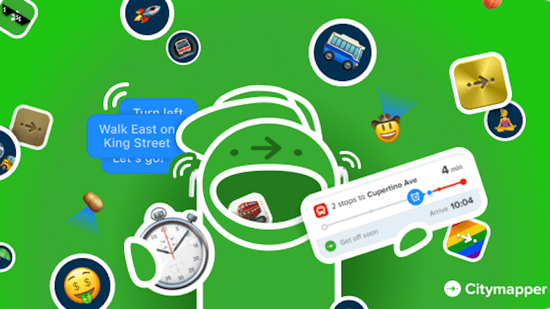
Since I am dependent on public transport myself, I have already tried out many apps. So today is about city mapper, a route planner for local transport in various metropolises. The app is about the AppStore and google play available and free of charge in the basic version.
The developers rely on banner advertising for financing, which users can hide by purchasing a subscription. Citymapper can currently be used in Germany in Berlin, Hamburg, Munich, Frankfurt, Cologne, Dortmund, Bremen, Hanover, Nuremberg and Stuttgart. My test covered the premium version and the version available in Munich.
Contents
Citymapper in the test: easy setup, reliable route planning
Launched the app, upon setup, Citymapper offers similar features to other apps on the market. After locating the location, the app automatically suggests the correct region. In the next step, users can add their favorites (e.g. home and work address).
The selection of the city and other minor adjustments such as the app icon and location icon can be adjusted via the settings. The calculation of a planned route is relatively easy. A search allows you to enter any address – regardless of whether it is a known place, station or street name.
As a starting point, Citymapper uses the current position of the user or – if this is not possible or desired – a previously defined address. Once the destination has been defined and the departure time set, the app searches for different routes to the destination. Basically, Citymapper offers about three to six different routes.
A display on the right compares the duration in minutes. In addition to calculating the route using public transport, the app also shows the duration and costs for e-scooters, mopeds, bicycles and taxis. The footpath option represents the calories burned to the destination. In addition to subway, S-Bahn, bus, tram and regional train, there are a number of route options.
Once you have decided on a route, Citymapper will guide you to your destination with or without voice navigation. The computer voice regularly indicates when you have to turn off on the way to a station or when you should leave the current vehicle. iPhone users can also view progress as live activity on the lock screen.
A slimmed-down app is also available for the Apple Watch. When you arrive at your destination, you can end the navigation manually and some statistics are available. Because Citymapper focuses on sustainability and shows you the emissions you have saved for all routes covered.
A car trip with a mid-range vehicle serves as a comparison. Another area gives an overview of your burned calories. The basis for this is a distance covered on foot. Even if the stats probably don’t add much value, the idea is innovative and well implemented.
Unfortunately no live departure times and dynamic planning
Let’s come to a negative point of Citymapper. Because the app (in Munich) does not offer one thing: live departure times. The tool plans trips based on static information. But if the S-Bahn is 20 minutes late and a detour by bus would be worthwhile, the app reaches its limits.
Also, no dynamic planning of routes is implemented. If a subway fails completely and you can’t make your connection, Citymapper is also overwhelmed. As a result, you have to cancel a current route and try planning a new route. And that’s the reason why I don’t see much added value in Citymapper yet.
Unplanned deviations in the timetable often occur again and again. At the same time, unforeseen events sometimes occur. If, for example, the local transport company goes on strike and the app recommends a route by subway, I stand helplessly in front of the locked bars. That should be better these days.
Citymapper in the test: conclusion
So what is left to say in conclusion? Citymapper is a great app that beats alternative offerings by far with its implementation. Live activities on the lock screen, an Apple Watch app or the display of the ecological footprint are features that have never been seen before.
Nevertheless, in my opinion, an investment in the app is not worthwhile. Because public transport is volatile, and especially in times of frequent disruptions and deviations, a tool is needed that can say in a matter of seconds how my trip is going.
If Citymapper manages to remedy this flaw in any way, the tool is a must-have for everyone who uses public transport. Until then, the app will remain just a nice gadget that offers a little more convenience.
Also interesting: